


2167 rezultatov
-
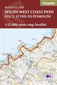 South West Coast Path Map Booklet - Vol 2: St Ives to Plymouth(2021) DILLON, PADDYMap of part of the southern section of the 630 mile (1014km) South West Coast Path National Trail. Covers the trail from St Ives to Plymouth along the west Cornwall and Devon coastline. This convenient and compact booklet of Ordnance Survey 1:25,000 mapsVezava: Mehka20,82 €
 -
 Pennine Way - the Path, the People, the Journey(2016) MCCLOY, ANDREWA portrait of the The Pennine Way, Britain and #039;s oldest and best known long-distance footpath, stretching 268 miles from the Peak District to the Scottish Borders. This personal, thoughtful and often humorous story of the path and #039;s remarkable hVezava: Mehka18,16 €
 -
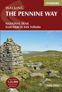 Pennine Way(2024) DILLON, PADDYGuidebook to the Pennine Way National Trail with OS map booklet. The 265 mile route from Edale to Kirk Yetholm takes three weeks to walk and is suitable for fit and experienced long distance walkers. The route crosses the Peak District, Yorkshire Dales anVezava: Mehka29,86 €
 -
 Walking in the New Forest(2021) DAVISON, STEVEA guidebook to 30 walks of between 3 and 10 miles set throughout the New Forest National Park in Hampshire and Wiltshire. Routes explore ancient woodland, heather-clad heath and dramatic coastline, all within easy reach of Southampton, Bournemouth and SalVezava: Mehka18,16 €
 -
 Walking in Kent(2024) REYNOLDS, KEVA guidebook describing 40 walks in the county of Kent. Covering west Kent and The Weald and north and east Kent, including the Kent Downs and the Greensand Hills. Walks of 5 to 9 miles explore rivers and coastline, beautiful countryside and historic villaVezava: Mehka24,04 €
 -
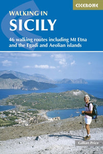 Walking in Sicily(2025) PRICE, GILLIANA walking guidebook with 46 graded routes in Sicily, including the Madonie and Nebrodi mountains, the Egadi and Aeolian islands and Mount Etna. Most walks take 3-4 hours, plus some short easy strolls as well as long mountain traverses. Interesting variedVezava: Mehka20,96 €
 -
 Hillwalking in Shropshire(2022) GILLHAM, JOHNGuidebook to 32 walking routes in Shropshire in the West Midlands. The routes range from 3 miles (5km) to 12 miles (19km), taking in highlights such as The Wrekin, Wenlock Edge, Long Mynd and Stiperstones, Castle Ring and Bury Ditches. Many routes start nVezava: Mehka18,16 €
 -
 Peddars Way and Norfolk Coast Path(2019) SMITH, PHOEBEThe 130 mile Peddars Way and Norfolk Coast Path National Trail combines the best of inland and coastal walking, and is ideal for people new to long-distance walks. Beginning near Thetford, the route heads north west to near Hunstanton, then follows the heVezava: Mehka18,16 €
 -
 Hebrides(2020) EDWARDS, PETERInspirational guidebook to 50 varied walking and backpacking routes in the Hebrides, featuring classics such as the Skye Cuillin and the Paps of Jura, but also many lesser-known routes on Jura, Scarba, Islay, Colonsay, Rum, Eigg, Canna, Muck, Coll, Tiree,Vezava: Mehka26,57 €
 -
 Day Walks in Northumberland(2021) WILSON, DAVIDDay Walks in Northumberland by David Wilson features 20 routes suitable for hillwalkers of all abilities. Together with stunning photography, each route features Ordnance Survey 1:25,000 maps, easy-to-follow directions, distance and navigation informationVezava: Mehka23,09 €
 -
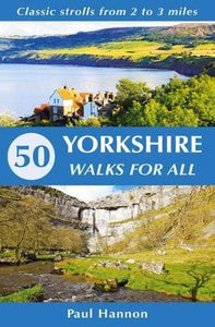 50 Yorkshire Walks for All(2019) HANNON, PAULThis new title is a celebration on foot of the glorious landmarks of Yorkshire, with the principle feature being that all walks are between 2 and 3 undemanding miles in length.Vezava: Mehka12,46 €
 -
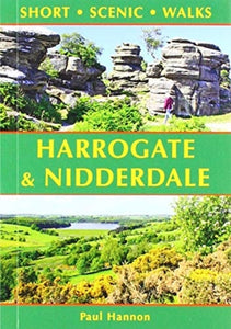 Harrogate & Nidderdale(2019) HANNON, PAULThis new title is one of the first two in an updated series of Paul Hannon's `Short Scenic Walks' guidebooks. The principle feature is that all walks are less than five miles in length, offering a perfect half day's stroll for families, casual walkers andVezava: Mehka8,90 €
 -
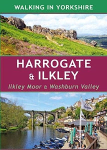 Harrogate & Ilkley(2019) HANNON, PAULThis book provides 25 enjoyable outings amid a rich variety of scenery. A collection of 40 colour photographs depict features and landscapes along the routes, while the concise route descriptions are complemented by a wealth of background information.Vezava: Mehka10,68 €
 -
 Norfolk(2022) SINCLAIR, JOPinpointing favourite treks, rambles and family trips, these 40 walks visit Norfolk in all its variety. From wild and windswept coast, Fens and Breckland to sheltered inland woods, broads and valleys, they offer geographical impact and a strong sense of hVezava: Mehka10,80 €
 -
 West Lothian(2019) MILNE, DOUGLASMidway between Glasgow and Edinburgh on the southern shore of the Firth of Forth, West Lothian has a surprising number of country parks, craggy hills and wildlife havens and is home to several prehistoric burial sites, ruined castles and palaces and stateVezava: Mehka10,80 €
 -
 Stirling & Falkirk(2021) DRAINEY, NICKhese 25 walks explore the picturesque places round Stirling and Falkirk, from the windswept drama of bare hills to the tranquill setting of canals, lochs, reservoirs and riversides.Vezava: Mehka10,80 €
 -
 Glasgow(2021) DRAINEY, NICKThese 25 walks explore the glorious architecture and parks at Glasgow's heart, as well as the best green places and built heritage within an hour's journey.Vezava: Mehka10,80 €


